Peddar's Way, Ringstead, North-West Norfolk.

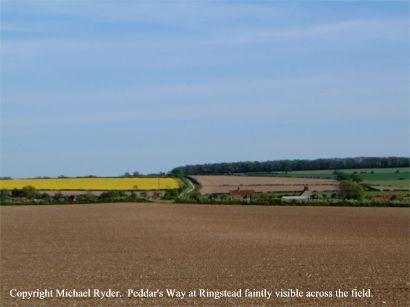
The photograph was taken from position Ordnance Survey TF 707
412 on 21st.May 2001 at 17.25 hrs.
Peddar's Way is the ancient roadway dating from Roman times, and where it
passes through the village of Ringstead, has over the centuries become
diverted from its original path. The track still appears at
certain times either after ploughing, or as crop marks. In this
photograph the path can be seen faintly visible across the field, leading from
bottom right towards an existing section of Peddar's Way alongside the yellow field
where it disappears over the horizon. The faint
whiteness of the path in the ploughed field of the foreground is the chalk
that once formed the road surface, still visible after centuries of
disuse. It would seem that the village developed to the west of the old
Peddar's Way, around the ruined church at Ringstead Bury and the existing
church in the High Street. The old Roman Road might then
have fallen into disuse, and gradually become abandoned to agriculture.
Peddar's Way can be traced on the map from Holme-next-the-Sea to Castle Acre,
and then on to connect with the Icknield Way near Thetford.
 Top
of Page Religious
Sanctuary Page Top
of Page Religious
Sanctuary Page
|