Walking
Holme-next-the-Sea offers lots of rambling opportunities for both the casual walker and the more dedicated hiker. There is a good choice of footpaths
in the village including a path that follows the River Hun, one that crosses a local nature reserve and another that follows the coastline.
The most popular footpath in the local area is The Peddars Way and North Coast Path.
This important footpath route is one of the National Trails and comprises two separate trails. The Peddars
Way, which starts at Knettishall in Suffolk and runs south to north to Holme-next-the-Sea where it joins the Norfolk Coast Path which runs east to west from Hunstanton
to Cromer. The total distance for the whole route is 150 km (93 miles) but fortunately it is easily walked in more manageable chunks!
It was announced in March, 2011 that Coast Awards 2011 had crowned the Norfolk Coast Path "Best Coastal Path"!
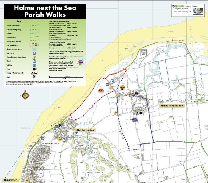
Outside the toilets, and near to the car park in Beach Road, Holme-next-the-Sea, Norfolk County Council has provided a large map showing the routes of three
suggested walks around the parish. They are all circular and start and finish at the map notice board.
This copy of the map is reproduced by kind permission of N.C.C. and the Ordnance Survey.

Click anywhere on the map for a larger version. If you enlarge it to 100% you will have to scroll around to see all the details...
Circular walk No. 1
is 5km/3m and follows the coastal path, with excellent views across The Wash, for part of the way and also meanders along the the north bank of the River Hun.
Circular walk No. 2
is 2.5km/1.5m also uses the coastal path for a while and then wanders across the eastern edge of Redwell Marsh, a nature reserve managed by the Norfolk Ornithologists' Association.
The White Horse pub in Holme-next-the-Sea conveniently pops up about two thirds of the way around the circuit!
Circular walk No. 3
is 4.7km/3m and takes in more of Holme-next-the-Sea village passing by the White Horse pub either early or later in the walk depending on which way you decide to hike.
Part of this route uses the Peddars Way, a footpath designated as one of the major National Trails.
A word of advice to the visiting walker! There is a lane in the village called 'Peddars Way' which, confusingly, does not follow the actual path of the Peddars Way
National Trail footpath. Please be warned!
Here are a few links to help you plan your walking based on Holme-next-the-Sea...
John Harris's Walking in Norfolk.
Explore Norfolk Holme Dunes Coastal Walk.
Walking Britain. Walk 3306 - Holme next the Sea and Thornham
The National Trail
This is a video of the National Trail section from the nearby village of Thornham to
Holme-next-the-Sea. Many thanks to YouTube for making this available - and special thanks to the Coasthopper fan who made the excellent video!
The England Coast Path
Natural England has started work on the England Coast Path – a new long-distance trail that will eventually allow people to walk around the whole English coast.
A route has already been proposed from Sea Palling to Weybourne and work has now started from Weybourne to Hunstanton. It is expected that the path will use the
existing route of the Norfolk Coast Path National Trail where this meets everyone’s needs, but there is scope to vary this where necessary.
There is more information about the England Coast Path in this leaflet about the work.
